2nd Ward (Old Frog Pond area)
Photo
courtesy of Carmela Straccione
Baseball team,
photo courtesy of Carmela Straccione
W.
2nd & Flower St.
Homes on W. 2nd St. built by Mr. Morris
Mailman
8th & Kerlin
Academy Hill
"Formerly the reference for the locality surrounding Pennsylvania Military
College, which previous to 1892 was known as Pennsylvania Military Academy."
(from the 1936 Chester Times Year Book).
Bethel Court
(Bevan St.) 12 East Second St, north to
East Mary St.
One can hardly cover the history of Chester without
mention of this section of town located below 3rd & Market St. Largely because of
Chester's function as a major shipping port, this "red light" district was known
worldwide. It was demolished in the mid 1950's.
Another of Bethel Court's claims to fame is that it was
the birthplace of Chester's Ethel Waters, perhaps
the best known African American performer of the 1930's and 1940's.
"The former name of Bevan Street, but now generally ascribed to the area bounded on the north by Third street, east by Welsh street, south by Second street and West by Market street."
(from the 1936 Chester Times Year Book).
Bickley Place
"We lived on Bickley Place, moving there in 1946.
Bickley Place was famous for 4 sets of twins, all girls. They were the Jenkins Twins
(Kathleen & Madeline), the Carr Twins (Edna & Alice), the Buller twins (Diane
& Nancy) and the Mulcahy twins (Ann & Betty). There was a write-up in the Chester
Times about it on December 15, 1951."
-Madeline A. Jenkins-Steiner, maddyjs@juno.com
Buckman Village
Boundaries:
North - 13th St.
East - Booth St.
South - 9th St.
West - Trainer Borough
"A war 'village' constructed by the Chester Emergency Housing Corporation and the United States Shipping Board, Emergency Fleet Corporation. Named for the former owner of the property, E. H. Buckman. Bounded on the north by Thirteenth street, east by Booth street, south by ninth street and west by Trainer Borough."
(from the 1936 Chester Times Year Book)
Thanks to Jack Ralston, Jfralston55@aol.com for passing along the following
notes:
Architect of Buckman Village:
Brumbaugh, George Edwin (1890 - 1983)
Born: 8/27/1890, Died: 1/29/1983
G. Edwin Brumbaugh, son of former Pennsylvania Governor Martin Grove Brumbaugh and Anna
Konigmacher Brumbaugh, was born in Huntingdon, PA. He graduated from Central High School
in Philadelphia and received his B.S. in Architecture from the University of Pennsylvania
in 1913.
During World War I, Brumbaugh was associated with the Emergency Fleet Corporation and with
the Philadelphia firm of Simon & Bassett, Architects, on Buckman Village in Chester,
Pa.
The Buckman Village project was a residential development for the Chester Shipbuilding Co.
(The Emergency Fleet Corporation). The development included 227 dwellings, one boarding
house for 25, one hotel, and 23 apartments.
Simon & Bassett, Architects (1905-1918), occupied an office at 1112 Chestnut Street,
Philadelphia.
Reference: http://www.philadelphiabuildings.org/
The Emergency Fleet Corporation was most likely the predecessor to The Sun Shipbuilding
Company. The hotel was more than likely the building at 10000 Meadow Lane. The apartment
buildings were along Keystone Road, along 10th Street between Keystone and Meadow Lane and
along Meadow Lane between 9th Street and 10th Street. For its time, the Buckman Village
development was beautifully conceived and executed.
Almost 90 years later, the Village is still thought of as one of the great neighborhoods
of Old Chester.
Article
& photo from the February 20, 1922 New York Times regarding the sale
of Buckman Village to be held on March 18, 1922. [Adobe pdf document
courtesy of Jack Ralston, 2/2/2009]
Chatham
Estates
Formerly Lamokin Village
Chatham Estates Senior Village
opened in July 2000.
In November 2000 ground was
broken for the Chatham Estates family development.
Downtown
Edgmont
Ave. between 10th & 12th St.
Market
Street photo courtesy of Joan Zueger Shorter, mommomjoan@aol.com
Commission
Row
Edgmont
Park
W 21st and 22nd Sts. from Edgmont Ave, over the Upland line to Upland Ave. Bordered on 21st St by the
Chester Rural Cemetery. Built in the late 40's
Eyre Park
Finland
"A Swedish designation in records for an undetermined part of the land bordering the Delaware river between Chester river (then Upland Kill) and Marcus Hook creek (then Marcus, or Chichester, creek). Of that period, and prior to 1675. That part of Finland next to the west bank of Chester river was called Printzdorf, and west from Lamokin run was called Lomoco from whence comes our present
Lamokin." (from the 1936 Chester Times Year Book)
Fishtown
"A former name, derived from the occupation of a large number of the inhabitants in
conducting shad, herring, and sturgeon fishing in the Delaware river, and bounded on the north by East and West Mary (Graham) street, east by Welsh street, south by Delaware river and west by Chester river (then creek)."
(from the 1936 Chester Times Year Book)
Flower Manor
"On the westend of Chester across from the Commodore Barry Bridge back in the 60's when Supt.
Clarence Roberts of Chester Schools lived over there in a big yellow house."
- Betty Shaw Woods, 660shaw@bellsouth.net
Forty Acres
"A development (so named because of its contents) begun after 1873 by Ward & Baker, and bounded on the north by Concord avenue, east by West of Norris street, south by North of Ninth Street, west by Flower street."
(from the 1936 Chester Times Year Book)
Freihofer Tract
"Between Sunnyside and Parkside Borough; and on the north side of Edgmont avenue,. Developed by Wm. Freihofer, of Philadelphia, beginning in 1915."
(from the 1936 Chester Times Year Book)
Frog Pond
"A favorite name formerly applied to the locality bounded on the north by Seventeenth street, east by Walnut street, south by Fifteenth street and west by Providence avenue."
(from the 1936 Chester Times Year Book)
"In regard to Frog Pond, Good Will Fire Co. No.2 located at 15th & Potter Sts. was in Frog Pond. The old timers at the fire company said there was a frog pond across from the old fire house that was full of frogs and that is where the name originated. The young fellows in the neighborhood had a baseball team called the Frog Pond.
Bufano's ["Two
Minute"] car wash is on part of the property where the pond was."
- Thanks to Bill Crystle
"I found an article re the 100th birthday
celebration of Helen Greenhalgh, which tells of her early years in a house where
Smedley School is now located. It also mentions Frog Pond, located in the same block as Smedley, where people used to skate."
- Thanks to Janet Andrews Moulder
Gallows Hill
"Twelfth street and Edgmont avenue. When Chester was the county seat, executions by hanging took place on the point formed by Providence and Edgmont avenues."
(from the 1936 Chester Times Year Book)
Goat Town
"Formerly applied to the neighborhood of Sixth and Wilson streets."
(from the 1936 Chester Times Year Book)
The Green
"The land south from the present [1936] Second street and from Chester river to Welsh street was originally Swedish Church Land (1669), though no edifice is known to have been erected there. The records of that period call it The green, and its reach into the river was of far greater proportions than at a later period when much of it had been washed away. Possession of this tract passed to David Lloyd in 1693."
(from the 1936 Chester Times Year Book)
The Gut
"The former name of Pancoast street and its environs." (from
the 1936 Chester Times Year Book)
Hannum's Hollow
"Where the McDade Boulevard bridge was constructed on the west bank of Ridley river, 1934-35."
(from the 1936 Chester Times Year Book)
Happy Valley
"An appellation appealing to the residents of Old Chester for the neighborhood bounded on the north by Third street, east by The Old Lewis' (now Aberfoyle) mill, south by Lewis street and west by Morton avenue.
The "Valley" has been removed and replaced by other improvements of the Aberfoyle Manufacturing
Company." (from the 1936 Chester Times Year Book)
Highland Gardens
Picture
at Perkins & Lehman Streets, 1961
courtesy of Ron Crowther
The Hill
"the area between W.9th St. and Concord Road and
included Verdon Ave. and Flower Street to Norris Street."
Growing Up in Black and White by Brent Staples.
Library of Congress Catalog Card Number:93-24258. This one tell quite a lot about
"The Hill".
Many thanks to TERRYABJT@aol.com
for this information
Hogtown
"A decisive name formerly applied by residents of Old Chester to those of the then Borough of South Chester. Thus a resident on the latter place was a "hogtowner." The "Hogtown Moon" was a pet name applied by all in the south part of Delaware County to the sky reflection at night produced by the blast furnaces of the old Tidewater Steel Company at Highland avenue and the river."
(from the 1936 Chester Times Year Book)
Holy City
- W. 8th St.
"Eighth street, west from Sproul street (late New Market street). Developed by J. Irvin Taylor beginning in 1905."
(from the 1936 Chester Times Year Book)
Irish Row
"Former name of Powell's Quarry north of Eighteenth street along west bank of Ridley river, where 2 rowhouses were occupied by the quarrymen."
(from the 1936 Chester Times Year Book)
Irvington
Hills
Northeast of 22nd St. overlooking
Ridley Creek
Jackville
"A group of 158 workers' dwellings constructed by the Chester Shipbuilding Co. Ltd., as part of the war activities in 1916-1917, and bounded on the north by Tenth street, east by East of Pennell street, south by Ninth street and west by Lamokin (Howell) street."
(from the 1936 Chester Times Year Book)
Johnson's Woods
"South side of Ninth street, opposite Meadow lane." (from
the 1936 Chester Times Year Book)
Lamokin
"That section of the city bordering on the P.B.& W.R.R., at its junction with the Chester Creek Railroad, and better symbolized by the railroad station of that name. The name has descended to us from land titles preceding Penn's first arrival in 1682."
(from the 1936 Chester Times Year Book)
Lamokin, or Young's Woods
"A former picnic grounds and camp meeting site of the Negro citizens. Bounded on the north by Tenth street, east by Chester Creek Railroad, south by Seventh street and west by west of Tilghman street."
(from the 1936 Chester Times Year Book)
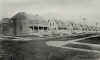
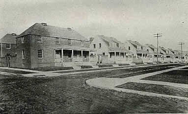
Lamokin Village
Property at 6th & Central Ave. was
acquired for the construction of Lamokin Village in 1939. Construction
was well underway by November 1941. In 2000 it was renamed Chatham
Estates
Groundbreaking
for Lamokin Village, August 2, 1940
Slide
show of Lamokin Village (c. 1941) & Bennett Homes (c. 1952) under
construction
Larkintown
"An almost forgotten designation of that part of Chester owned and developed (1850-1881) by the first Mayor of Chester. John Larkin, Jr., and bounded on the north by Rose street, east by Morton avenue, south by Sixth street and west by Crosby street and Edgmont avenue."
(from the 1936 Chester Times Year Book)
That part of Chester owned and
developed by the first Mayor of Chester, John Larkin, Jr.
Boundaries:
North - Rose St.
East - Morton Ave.
South - 6th St.
West - Crosby St. & Edgmont Ave.
Lytle's Woods
"Now embraced within the limits of Crozer Park." (from the
1936 Chester Times Year Book)
McCaffery Village
Carl DeLurio remembers that when McCaffery
Village was first proposed, there was a sign on the site announcing the
development of "Thurlow Acres". (Pictures
from The Delaware County Advocate, July 1942)
Lt.
Colonel Hugh F. McCaffery (Picture and story from The Delaware
County Advocate, August 1942.)
The new development on this site is known as Wellington Ridge
Market Place
"The present [1936] Market Square where from about 1701-1857 foregathered the people of Old Chester for their marketing in the Market House, their shopping in the stores surrounding the Place, and in the second story of the House for their deliberations on official and social matters."
(from the 1936 Chester Times Year Book)
The Marsh
"Also referred to as meadows, reeds, or flats--the old gunning precinct of Chester's sportsmen extending along the river from Welsh street to Ridley river (then creek). This hunting ground ceased with the filling in of the marsh about 1907."
(from the 1936 Chester Times Year Book
Matopos Hills
Formerly Ruth L. Bennett Homes
Mount Mellick
"The high ground where Concord avenue abuts Crozer Park. So designated in records from early times down to the occupancy of the Lytle family."
(from the 1936 Chester Times Year Book)
Ninth St.
View
on E. 9th St.
View
on W. 9th St.
North Chester
"A former Borough incorporated in 1873 and merged with the City of Chester in 1887. It is now
represented by the First Ward of the City." (from the 1936 Chester
Times Year Book)
Old North Ward
"Bounded on the north by a line drawn east from Sixteenth street and Edgemont avenue to Ridley river (then creek) at Eighteenth street, east by Ridley river, south by P.B. & W. (Penna.) Railroad and west by Chester river (then creek) and Ship creek."
(from the 1936 Chester Times Year Book)
Old Middle Ward
"Bounded on the north by P.B. & W. (Penna.) Railroad, east by Ridley river (then creek), south by Delaware river and by Chester river (then creek)."
(from the 1936 Chester Times Year Book)
Old South Ward
"Affectionately perpetuated into eh minds of Chester folks by John E. McDonough in his book "Idyls of the Old South Ward" (1933) and bounded on the north by a line drawn from Tenth and Broomall streets, east to Chester river (then creek) above Eleventh street, east by Chester river, south by Delaware river and west by Lamokin run (then the eastern limit of South Chester Borough)."
(from the 1936 Chester Times Year Book)
"Over the Bridge"
"For close to 150 years, the only contact between residents of Chester on each bank of Chester creek (then river) was by the James street, or Third Street bridge, so that to those on the east bank anyone living on the west bank was
'over the bridge'" (from the 1936 Chester Times Year Book)
Park Place
Boundaries:
West - Gray St.
North - Edgmont Ave.
East - 23rd St.
South - Upland Borough
"Developed by Frederick A. and William E. Howard and James A.G. Campbell, beginning about 1903, and bounded on the northwest by Gray street (formerly 26th street), northeast by Edgmont avenue, southeast by Twenty-third street and southwest by Upland Borough."
(from the 1936 Chester Times Year Book)
Park Villas
North - Crozer Park
East - Kerlin St.
South - B&O Railroad
West - Crozer Park
"Developed by The Montray Realty Corp., a New York syndicate, beginning in 1917, and bounded on the north by Crozer Park, east by Kerlin street, south by B. & O. R.R. and west by Crozer Park."
(from the 1936 Chester Times Year Book)
Paultown
"Named for one Paul who had a leather factory where the group of old dwellings still stand
[1936] at Twenty-fourth and Potter streets." (from the 1936
Chester Times Year Book)
Penn Homes
Potter St.
View
on Potter St. near 13th
Powhattan
Boundaries:
North - Rural Avenue
East - Edgmont Ave.
South - 14th St.
Southwest - Upland Ave.
"A 'village' which grew around and due to the mill industries of
Shaw and Esrey, beginning about 1867-bounded on the north by Fifteenth street, east by Edgmont avenue, sough by Fourteenth street and southwest by Upland avenue."
(from the 1936 Chester Times Year Book)
Price Tract
Boundaries:
North - Chester River
East - Chester River
South - 9th St.
West - Penn St.
"A development by Wm. G. Price, Jr. commencing about 1912, and bounded on the north by Chester river, east by Chester river, south by Ninth street and west by Penn street."
(from the 1936 Chester Times Year Book)
Providence Heights
North - 21st St.
East - Washington Blvd.
South - 18th St.
West - Hyatt St.
"Owned and developed by Nolan Brothers, beginning about 1905, and bounded on the north by Twenty-first street, east by Washington blvd, and Ridley avenue, south by Eighteenth street and west by Hyatt street."
(from the 1936 Chester Times Year Book)
Ruth L. Bennett Homes
Named for Mrs. Ruth L. Bennett,
president of the Ruth L.
Bennett Improvement Club, Inc. from its organization in 1914 until 1947.
Slide
show of Lamokin Village (c. 1941) & Bennett Homes (c. 1952) under
construction
In 2000 was renamed Matopos
Hills
Sharpless' Woods
"A former picnic grounds used by the Churches of Old Chester. bounded on the north by Ridley creek, east by Chestnut street, south by about Twenty-fourth street and west by Upland street."
(from the 1936 Chester Times Year Book)
Ship Creek Woods
"In the valley of the creek of that name north and south from Fourteenth street (Upland avenue). Particularly that part lying south, and connecting with the present
Deshong Memorial Park on Chester river. Almost the last vestige of this once a magnificent woodland was removed during the trying period beginning in 1929. The late
Louise Deshong Woodbridge has perpetuated the former beauties of these woods on canvas and with the camera."
(from the 1936 Chester Times Year Book)
Shoemakerville
An old designation for the
neighborhood from 24th & Chestnut Streets to 24th St. & Providence
Ave. & Northeast to Ridley Creek.
"An aged designation for the neighborhood of from Twenty-fourth and Chestnut streets to Twenty-fourth streets and Providence avenue and northeast to Ridley creek. Thus a resident of this area was called a
'Shoetowner.'" (from the 1936 Chester Times Year Book)
Shoemakerville
Hill - Photo from the Delaware County Advocate, July 1940
Simpson's Woods
"Bounded on the north by Eighteenth street, east by Ridley river, south by Seventeenth street and west by Melrose avenue. This woods still exists and, prior to the opening of Seventeenth street, about 1904, extended somewhat south of said street."
(from the 1936 Chester Times Year Book)
South Chester
"A former Borough incorporated in 1870 and merged with the city of Chester in 1898, and bounded on the north by Concord and Bethel avenues, east by, in part, Lamokin run, south by Delaware river and west by Upper Chichester Township and Lower Chichester Township (now Trainer Borough). Now embraced by the Ninth, Tenth and Eleventh Wards."
(from the 1936 Chester Times Year Book)
Stone Row
"A former designation of the Negro settlement in the neighborhood of the northwest corner of Seventeenth and Chestnut streets."
(from the 1936 Chester Times Year Book)
Sun Hill
Boundaries:
North - 17th St.
East - Ridley River
South - B&O Railroad
West - Melrose Ave.
Sun Hill was built in the early
1900's to house the management employees of Sun
Ship.
"I grew up in Sun Hill in the 50's and 60's and
think it deserving of a page due to it's proximity to then PMC
college. Sun Hill and Sun Village were constructed circa 1916/1917 to house the white
collar and blue collar workers of Sun Ship."
- John H. Rhoads
III
Sun Village
Boundaries:
North - B&O Railroad
East - Ridley River
South - 9th St.
West - Elsinore Place
"Bounded on the north by B. & O. R.R. east by Ridley river, south by Ninth street and west by Elsinore place. These "villages" were constructed in 1918, as part of the war program contributed by the Sun Realty Co. and North Chester Realty Co."
(from the 1936 Chester Times Year Book)
Sun Village was built in the early
1900's to house the employees of Sun Ship.
Demolition
of stores along Morton Ave. - February 6, 2003 photo courtesy of Harvey
S. Martin
"I grew up in Sun Village and lived there from 1960 to 1991. I remember allot about the village. It was full of families that all knew each other and grew up together for generations. My grandparents lived on Morton Ave., at the time Sears & Roebucks home and garden center was across the street, and Pop's Texaco service station. My first recollection of gas was 25 cents a gallon. My aunt and uncle lived on Vaulcain between Curry and Remington. I had cousins that lived on Thomas street between Johnson and Terrill. We lived on Terrill and
Remington right on the corner. I remember all the great stores that were on Morton avenue from Terrill down to Baldwin and over to Melrose avenue. For all of us from the village let me see if I can give the vision I remember. On the left side going down Morton avenue toward down town Chester, there was
Fowlkes' jewelry, a few homes, then the barber shop, "Squires" hoagie shop, still the best hoagie I've ever tasted, and there was a beauty shop, and bakery, Hutchinson's pharmacy where
everyone knew Vernon the pharmacist, the Sunset Café, the Sun Village Boys Club, then looking down the right side, was the Sun Village Sports Club, where they would run trips to see the
Phillies!! I remember my first trip to a game cost $1.00 and that was the bus ride, a hoagie and your ticket, they would also hold meeting for the brownies and girl scouts, then there was Pepple's printing and you could go in and get a great ice cream cone, hand dipped, you would see Betty or Harry or their kids. Next was everyone's favorite store ....... Ryan's. Eddie Dodds was the proprietor for all of my life. He was a friendly happy soul, and everyone knew Eddie and Eddie knew everyone. I had the pleasure of growing up next door to his daughter Sarah Jane Rounds, my birthday buddy. Eddie was also involved in all types of sports and helped organize the boys club. Eddie was also known for helping out families who needed food and didn't have the money to pay at the time. He seen a lot of us thru tough times, and was always gracious. Now on to the bar, then another favorite store was the 5 & 10. It had anything you needed. A great toy room in the back. My brother Bob and I would go there and buy things all the time, it was our first line of credit, where we would run a small bill and pay 25 cents a week or so, until our mom found out,
haha. You would always see Etta and Hannah, and again, everyone knew everyone. Then there was the Eureka store,
Mallas' market which later closed and was another grocery store, Iggy's I think. Then the famous Joe's hardware and only store with an office post office in it, with Joe being the post master there. At the very end there was the Melrose dinner, which closed sometime in the late 60's, I was very young, but remember going there with my grandmother for soft ice cream. At the center of Sun Village there was v shaped spot of ground in the center where Morton Ave. and 12th street would meet, each year there would be a beautiful Christmas tree lit with all the different colors, the old big bulbs. Behind that was Fisher and Sons Plumbing, then the Goodwill, and good old
Eddie's Café, where everybody
knows our name! At the top of the village along Handcock street was where the big old interstate 95 ran thru and separated Sun Village and Sun Hill. Sun Village was the edge of Chester next door to Eddystone. We had the field at Curry street,
Sun Village Park, that ran from Vaulclain to Terrill to Johnson, along Thomas, and Baldwin, and over to 9th street. There was Brown street, where June's hairdressing was on the corner, then White street, and Remington.
I remember seeing a lot of friendly faces, maybe
some of these names ring a bell, Frank & Ann Poiste, Tootsie Trader, Mrs. Kennedy, and Mrs, Tambuzzi, Mrs, Angie Fiorelli, the Barbers, the Gehrings, the Christ family and Giampalmi's, the Phillips family, the Halls, Sal and Bill Rounds, the Billets, Mr. and Mrs. Walter Jackson, the lawn man. The Di caves, Runners, Downes, Linda, Vincent & Billy Di prinzio, the Morgans, the Lavaiques, Woodrows, Teofiliaks, Buffano's, the Bunnels, the Beltz's, the Ruhls, the Rue family, the Laverty's, the Barones, the Powells, the Wachter's, Wrights, the Donohues, the O'briens, the Vida, the Whites, the Mc Andrews, Elliots, the Fiorelli's, the Dodds, the Caffo family, the Seifert's, the Hausmans, the Mc Crays, geez, to name a few, oh and the Boyle bunch. I have good memories of Sun Village, I hope some one else writes in and shares about it too."
- P. Boyle
Sunnyside
Boundaries:
North - Chester Park
East - Madison St.
South - 24th St.
West - Worrell St.
"Owned and developed by E.S. Worrell beginning about 1887, and bounded on the north by Chester Park, east by Madison street, south by Twenty-fourth street and west by Worrell street and Elkinton boulevard."
(from the 1936 Chester Times Year Book)
Thurlow
"A name, in honor of the late John J.
Thurlow, applied to the section abutting Highland avenue; the former name of the Highland avenue station of the P.B. & W. (Penna.) R.R."
(from the 1936 Chester Times Year Book)
Thurlow Acres (see McCaffery
Village)
Upland
"The Swedish and Dutch name for Chester prior to Penn's first coming in 1682. At that time, the town lots bordered only
the east bank of Chester creek (then Upland Kill) from the Delaware river "backwards," or northwardly to approximately the present Third street, though Upland at large embraced an area from Chester river as far east as Ridley river, and as far north as the southerly limits of Brookhaven."
(from the 1936 Chester Times Year Book)
Wellington Ridge
A new development on the site of the former McCaffery Village.
Ground-breaking ceremonies to mark the
start of construction were held on October 2, 2001.
West End
View
of Highland Ave. toward 9th St.
William Penn Projects (See Penn
Homes)
|